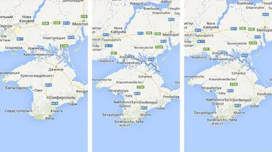
Google Maps drew up three different topographical plans of Crimea: one for visitors from Ukraine, another one for Russian users; and the third on the international version of the site.
“People generally assume that, well, science is just objective, and what we do in cartography is represent the world ‘out there’. But it’s never as clear cut,” explains Christine Leuenberger, Cornell University professor who researches politics and cartography. “Maps are always selective. You always have to omit as much as you include. So they’re always political. It’s impossible to construct an apolitical map.”
So, Google decided which geopolitical truth to tell you based on which country's version of Google you are using. For people located in Ukraine, Google Maps left Crimea as a part of Ukraine, as it looked before Russia’s invasion. But it changed the map for users accessing the site from Russia, showing Crimea as separate from Ukraine with a thick line. International visitors see a version with a dotted line, the sign of a disputed border.
In mapmaking, who establishes where the borders fall?
Find more on BBC Travel


Comments (0)
Share your thoughts and join the technology debate!
No comments yet
Be the first to share your thoughts!