'Atlantis' Turns out to be Interfacial Artefact
Koert van MensvoortSince the days of Plato, the lost city of Atlantis has captivated the imagination of many. The city, if you don’t already know, was said to be a naval power located roughly 600 miles west of the Canary Islands…until it sank.
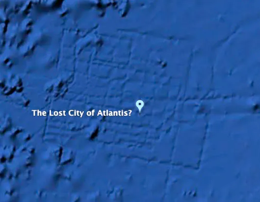
While browsing through Google Earth’s new underwater search tool, British aeronautical engineer Bernie Bamford sighted a mysterious grid of undersea lines. The strange pattern was spotted in the Atlantic ocean, west of Morocco in North Africa, close to one of the possible sites of the legendary island.
The story was reported by The Daily Telegraph – a national UK newspaper – as well as by UK Tabloid Sun. However, Google later confirmed that the Atlantic floor pattern, measuring about the size of Wales, was an 'artefact' of its map-making process. The maps are made using sonar measurements of the sea floor recorded by boats. The area in question was mapped by boats traveling in straight lines, a Google spokeswoman revealed.
"It's true that many amazing discoveries have been made in Google Earth including a pristine forest in Mozambique that is home to previously unknown species and the remains of an Ancient Roman villa. In this case, however, what users are seeing is an artifact of the data collection process," she said.
Whether we are roaming the globe with Google Earth, descending into the depths of our genes or traveling to the outskirts of the universe, our world view is fundamentally shaped through interfaces.
See also: World View, Earth rise on Youtube, To boldly Google.., The Metaverse Roadmap.
Comments (0)
Share your thoughts and join the technology debate!
No comments yet
Be the first to share your thoughts!